 U.S.
JGOFS Synthesis & Modeling Project U.S.
JGOFS Synthesis & Modeling Project
U.S.
JGOFS Synthesis & Modeling Project U.S.
JGOFS Synthesis & Modeling Project
|
|
|
|
|
|
|
|
|
|
|
|
|
|
|
|
|
|
|
|
|
|
|
|
|
|
|
|
|
|
|
|
|
|
|
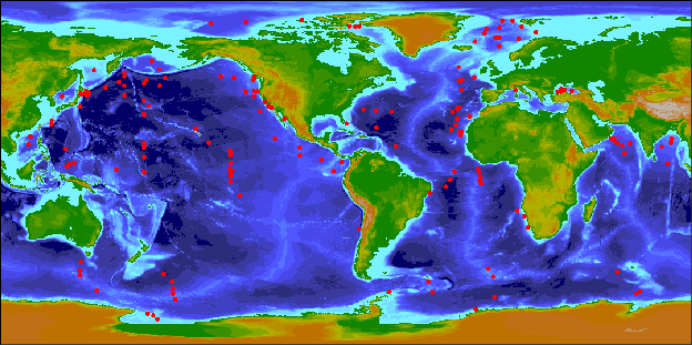
| The entire global sediment trap data set, which includes all annual and time-series flux data from all 193 trap locations, is available for download as a single .tar file. Alternatively, selections of the data may be viewed by clicking the links and buttons in the master table below. |
|
Global
Sediment Trap Results
|
||||||||
|
Atlantic Ocean |
||||||||
Data Help |
Geographic Region | Project ID | Lon. |
Lat. |
Number of Traps |
Start Year |
Duration (days) |
Please use appropriate reference when citing this data. |
|
|
Atlantic-Nordic Sea | Fram Strait-SP | 6.74 |
78.89 |
3 |
1987 |
361 |
|
|
|
Atlantic-Nordic Sea | PARFLUX-Fram Strait-FS | 1.37 |
78.86 |
1 |
1984 |
358 |
|
|
|
Atlantic-Nordic Sea | Fram Strait FS3 | 0.18 |
78.76 |
1 |
1987 |
350 |
|
|
|
Atlantic-Nordic Sea | Fram Strait FS4 | -4.10 |
78.44 |
1 |
1988 |
332 |
|
|
|
Atlantic-Nordic Sea | PARFLUX-Bear Island-BI | 11.47 |
75.86 |
1 |
1984 |
362 |
|
|
|
Atlantic-Nordic Sea | PARFLUX-Greenland Basin-GB | -6.72 |
74.58 |
1 |
1985 |
364 |
|
|
|
Atlantic-Nordic Sea | PARFLUX-Barents Sea | 19.00 |
73.00 |
1 |
1989 |
365 |
|
|
|
Atlantic-Nordic Sea | Greenland Sea-OG | -8.00 |
72.50 |
3 |
1988 |
365+ |
|
|
|
Atlantic-Nordic Sea | PARFLUX-Jan Mayen-NB | -1.96 |
70.00 |
1 |
1985 |
204 |
|
|
|
Atlantic-Nordic Sea | Norwegian Sea-NB | 0.00 |
70.00 |
3 |
1986 |
365+ |
|
|
|
Atlantic-Nordic Sea | PARFLUX-Lofoten Basin-LB | 10.00 |
69.50 |
1 |
1983 |
352 |
|
|
|
Atlantic-Nordic Sea | MRI-PARFLUX-Iceland Plateau-IP | -12.66 |
68.00 |
1 |
1986 |
365+ |
|
|
|
Atlantic-Nordic Sea | PARFLUX-Aegir Ridge-NA-1 | 1.10 |
65.52 |
1 |
1985 |
299 |
|
|
|
Atlantic-North | L3-92; L3-93 | -21.23 |
54.65 |
2 |
1993 |
365+ |
|
|
|
Atlantic-North | OMEX-2,3,4 | -13.00 |
49.18 |
3 |
1993 |
365+ |
|
|
|
Atlantic-North | BOFS-48N | -19.50 |
47.83 |
1 |
1989 |
512 |
|
|
|
Atlantic-North | L2-AB-92 | -19.65 |
47.83 |
1 |
1992 |
425 |
|
|
|
Atlantic-North | L2-B-92 | -19.78 |
47.80 |
3 |
1992 |
365+ |
|
|
|
Atlantic-North | L2-93, 94 | -19.80 |
47.80 |
7 |
1993 |
363 |
|
|
|
Atlantic-North | JGOFS-NABE-48N | -20.87 |
47.72 |
3 |
1989 |
358 |
|
|
|
Atlantic-North | Dutch JGOFS-47N | -20.84 |
47.67 |
2 |
1990 |
23 |
|
|
|
Atlantic-North | L2-93-(58) | -19.80 |
42.80 |
1 |
1993 |
269 |
|
|
|
Atlantic-North | JGOFS-NABE-34N | -21.02 |
33.82 |
3 |
1989 |
344 |
|
|
|
Atlantic-North | L1-93 | -21.98 |
33.15 |
2 |
1993 |
346 |
|
|
|
Atlantic-North | L1-94, 95 | -22.02 |
32.95 |
3 |
1994 |
382 |
|
|
|
Atlantic-North | Hatteras Abyssal Plain-33N-HAP | -70.82 |
32.73 |
1 |
1982 |
325 |
|
|
|
Atlantic-North | Sargasso Sea SCIFF-32N | -64.25 |
32.08 |
3 |
1978 |
365+ |
|
|
|
Atlantic-North | Sargasso Sea-OFP | -64.17 |
31.83 |
3 |
1984 |
365+ |
|
|
|
Atlantic-North | BOFS-31N | -24.67 |
31.55 |
1 |
1985 |
326 |
|
|
|
Atlantic-North | PARFLUX-Sohm Abyssal Plain-S | -55.92 |
31.54 |
3 |
1976 |
110 |
|
|
|
Atlantic-North | ESTOC(CI-1,CI-2) | -15.42 |
29.12 |
2 |
1991 |
495 |
|
|
|
Atlantic-North | BOFS-28N | -21.98 |
28.00 |
1 |
1996 |
294 |
|
|
|
Atlantic-North | Northwest Providence Channel-(NWPC) | -79.50 |
25.30 |
1 |
1985 |
116 |
|
|
|
Atlantic-North | BOFS-25N | -22.83 |
24.55 |
1 |
1990 |
348 |
|
|
|
Atlantic-North | Nares Abyssal Plain-23N-NAP | -63.98 |
23.20 |
1 |
1983 |
403 |
|
|
|
Atlantic-North | BOFS-22N | -25.23 |
21.93 |
1 |
1986 |
150 |
|
|
|
Atlantic-North | Cape Blanc-CB-1,2,3,4 | -20.67 |
21.13 |
4 |
1989 |
365+ |
|
|
|
Atlantic-North | BOFS-19N | -20.18 |
19.00 |
1 |
1990 |
224 |
|
|
|
Atlantic-North | PARFLUX-Demerara Abyssal Plain-E | -54.00 |
13.50 |
4 |
1977 |
98 |
|
|
|
Atlantic-North | Cape Verde Islands-CV1 | -21.00 |
11.50 |
2 |
1992 |
365+ |
|
|
|
Atlantic-North | Guinea Basin North-GBN | -11.13 |
1.80 |
2 |
1989 |
365+ |
|
|
|
Atlantic-South | Equator-EA | -10.80 |
0.00 |
2 |
1991 |
365+ |
|
|
|
Atlantic-South | Equator-WA8 | -23.50 |
0.00 |
1 |
1994 |
357 |
|
|
|
Atlantic-South | Guinea Basin South, GBZ4, GBZ5, EA4 | -9.90 |
-2.18 |
3 |
1989 |
365+ |
|
|
|
Atlantic-South | WA1,4,7 | -25.70 |
-4.00 |
2 |
1992 |
365+ |
|
|
|
Atlantic-South | EA5 | -10.30 |
-4.30 |
1 |
1991 |
230 |
|
|
|
Atlantic-South | EA8 | -9.40 |
-5.80 |
1 |
1991 |
296 |
|
|
|
Atlantic-South | WA2,3,6 | -28.00 |
-7.50 |
2 |
1992 |
153 |
|
|
|
Atlantic-South | Eastern Brazil-Sao Francisco River Area | -36.22 |
-10.93 |
1 |
1995 |
126 |
|
|
|
Atlantic-South | Walvis Ridge-WR-1,2,3,4 | 9.17 |
-20.07 |
2 |
1988 |
365+ |
|
|
|
Atlantic-South | North Benguela-Walvis Bay | 12.90 |
-23.00 |
1 |
1989 |
120 |
|
|
|
Atlantic-South | NU2-29S | 14.60 |
-28.90 |
1 |
1992 |
380 |
|
| |
||||||||
|
Indian Ocean |
||||||||
Data Help |
Geographic Region | Project ID | Lon. |
Lat. |
Number of Traps |
Start Year |
Duration (days) |
Please use appropriate reference when citing this data. |
|
|
Indian-Arabian Sea | Indo-German Arabian Sea-W | 60.00 |
16.00 |
2 |
1987 |
365+ |
|
|
|
Indian-Arabian Sea | Indo-German Arabian Sea-C | 64.00 |
14.00 |
2 |
1987 |
365+ |
|
|
|
Indian-Arabian Sea | Indo-German Arabian Sea-E | 68.00 |
15.00 |
2 |
1987 |
365+ |
|
|
|
Indian-Arabian Sea | JGOFS-Arabian Sea-M1 | 57.85 |
17.69 |
2 |
1994 |
391 |
|
|
|
Indian-Arabian Sea | JGOFS-Arabian Sea-M2 | 58.80 |
17.40 |
4 |
1994 |
391 |
|
|
|
Indian-Arabian Sea | JGOFS-Arabian Sea-M3 | 59.59 |
17.21 |
4 |
1994 |
391 |
|
|
|
Indian-Arabian Sea | JGOFS-Arabian Sea-M4 | 61.50 |
15.33 |
3 |
1994 |
391 |
|
|
|
Indian-Arabian Sea | JGOFS-Arabian Sea-M5 | 65.00 |
10.00 |
3 |
1994 |
391 |
|
|
|
Indian-Bay of Bengal | Indo-German Bay of Bengal-17N-NBBTn | 89.60 |
17.45 |
2 |
1987 |
365+ |
|
|
|
Indian-Bay of Bengal | Indo-German Bay of Bengal-15N-NBBTs | 89.17 |
15.23 |
2 |
1990 |
365+ |
|
|
|
Indian-Bay of Bengal | Indo-German Bay of Bengal-13N-CBBT | 84.37 |
13.15 |
2 |
1987 |
365+ |
|
|
|
Indian-Bay of Bengal | Indo-German Bay of Bengal-4N-SBBT | 87.30 |
4.46 |
2 |
1987 |
365+ |
|
| |
||||||||
|
Pacific Ocean |
||||||||
Data Help |
Geographic Region | Project ID | Lon. |
Lat. |
Number of Traps |
Start Year |
Duration (days) |
Please use appropriate reference when citing this data. |
|
|
Pacific-Marginal Sea | PARFLUX-Bering Sea | 179.00 |
58.00 |
1 |
1991 |
330 |
|
|
|
Pacific-Marginal Sea | Aleutian Basin-Bering Sea-AB | -177.00 |
53.50 |
1 |
1990 |
365+ |
|
|
|
Pacific-Marginal Sea | PARFLUX-Okhotsk Sea-OS | 149.00 |
53.00 |
2 |
1990 |
365 |
|
|
|
Pacific-Marginal Sea | KORDI-East/Japan Sea | 132.40 |
39.67 |
1 |
1994 |
366 |
|
|
|
Pacific-Marginal Sea | South China Sea-North-SCS-N | 116.02 |
18.47 |
1 |
1987 |
396 |
|
|
|
Pacific-Marginal Sea | South China Sea-Central-SCS-C | 115.10 |
14.60 |
1 |
1990 |
365+ |
|
|
|
Pacific-Western | IOS-Sub-Arctic-GD | 165.00 |
51.50 |
1 |
1991 |
336 |
|
|
|
Pacific-Western | 50N | 165.00 |
50.00 |
3 |
1997 |
365+ |
|
|
|
Pacific-Western | NP3 | 176.34 |
47.85 |
3 |
1978 |
30 |
|
|
|
Pacific-Western | Station 8 | 175.32 |
46.12 |
1 |
1993 |
304 |
|
|
|
Pacific-Western | IOS-Sub-Arctic-GA | 165.00 |
45.00 |
1 |
1991 |
336 |
|
|
|
Pacific-Western | WP4 KNOT HU | 155.03 |
44.07 |
1 |
1989 |
325 |
|
|
|
Pacific-Western | KNOT | 155.00 |
44.00 |
3 |
1997 |
365+ |
|
|
|
Pacific-Western | KURU-40N | 165.00 |
40.00 |
3 |
1997 |
365 |
|
|
|
Pacific-Western | WP3 | 145.43 |
40.00 |
1 |
1984 |
220 |
|
|
|
Pacific-Western | Station 7 | 174.95 |
37.40 |
2 |
1993 |
313 |
|
|
|
Pacific-Western | Station 5 | 177.74 |
34.42 |
2 |
1993 |
304 |
|
|
|
Pacific-Western | Japan Trench-JT | 141.98 |
34.17 |
4 |
1992 |
365 |
|
|
|
Pacific-Western | Station 6 | 175.00 |
30.00 |
1 |
1993 |
334 |
|
|
|
Pacific-Western | JAST01-Okinawa Trough | 127.00 |
27.00 |
2 |
1993 |
365+ |
|
|
|
Pacific-Western | JAST03-Ryukyu Trench | 127.00 |
25.00 |
1 |
1994 |
306 |
|
|
|
Pacific-Western | CP15 | 175.02 |
15.00 |
1 |
1990 |
342 |
|
|
|
Pacific-Western | North Equatorial Current-NEC | 134.29 |
12.01 |
2 |
1988 |
390 |
|
|
|
Pacific-Western | Equatorial Pacific-Site 4 | 175.01 |
7.93 |
2 |
1992 |
200 |
|
|
|
Pacific-Western | Equatorial Counter Current-ECC | 138.83 |
5.01 |
2 |
1988 |
390 |
|
|
|
Pacific-Western | Site 2 | 136.28 |
4.13 |
2 |
1991 |
300 |
|
|
|
Pacific-Western | Site 1 | 135.00 |
3.00 |
2 |
1991 |
330 |
|
|
|
Pacific-Western | Site 10 E98 | 160.57 |
1.22 |
1 |
1994 |
197 |
|
|
|
Pacific-Western | Site 3 | 175.16 |
0.00 |
2 |
1992 |
289 |
|
|
|
Pacific-Western | Site 11 | 155.99 |
-12.99 |
1 |
1995 |
321 |
|
|
|
Pacific-Western | Site 12 | 154.83 |
-17.76 |
2 |
1995 |
305 |
|
|
|
Pacific-Western | Site 13 | 161.00 |
-35.52 |
1 |
1995 |
245 |
|
|
|
Pacific-Eastern | IOS-Ocean Station Papa OSP | -145.00 |
50.00 |
3 |
1983 |
365+ |
|
|
|
Pacific-Eastern | Vancouver Island slope-G | -127.63 |
49.65 |
1 |
1994 |
237 |
|
|
|
Pacific-Eastern | Vancouver Island slope-O | -127.75 |
49.12 |
1 |
1994 |
365 |
|
|
|
Pacific-Eastern | IOS North Pacific Station P-C | -138.00 |
49.00 |
1 |
1985 |
348 |
|
|
|
Pacific-Eastern | Sub Arctic-SA | -174.00 |
49.00 |
1 |
1990 |
365+ |
|
|
|
Pacific-Eastern | Vancouver Island Slope-S | -127.98 |
48.78 |
1 |
1994 |
350 |
|
|
|
Pacific-Eastern | California Current-Juan de Fuca Ridge-JDF | -128.10 |
47.97 |
1 |
1984 |
335 |
|
|
|
Pacific-Eastern | IOS-Sub-Arctic-GB | -177.00 |
45.00 |
1 |
1991 |
336 |
|
|
|
Pacific-Eastern | California Current-Midway-MW | -127.58 |
42.19 |
1 |
1987 |
352 |
|
|
|
Pacific-Eastern | California Current-Near Shore-NS | -125.77 |
42.09 |
1 |
1987 |
360 |
|
|
|
Pacific-Eastern | California Current-Gyre-G | -132.00 |
41.55 |
1 |
1987 |
364 |
|
|
|
Pacific-Eastern | California Current-Mendocino Fracture Zone-MFZ | -127.69 |
39.49 |
6 |
1983 |
358 |
|
|
|
Pacific-Eastern | Monterey Bay-S1 | -122.05 |
36.73 |
1 |
1989 |
365+ |
|
|
|
Pacific-Eastern | Santa Barbara Basin | -120.02 |
34.23 |
1 |
1993 |
365+ |
|
|
|
Pacific-Eastern | San Pedro Basin | -118.50 |
33.55 |
1 |
1988 |
159 |
|
|
|
Pacific-Eastern | EP7 | -124.60 |
31.70 |
5 |
1982 |
40 |
|
|
|
Pacific-Eastern | Gulf of California-Guaymas Basin | -111.66 |
27.88 |
1 |
1990 |
365+ |
|
|
|
Pacific-Eastern | HOTS | -158.00 |
22.75 |
4 |
1992 |
365+ |
|
|
|
Pacific-Eastern | EP11 | -117.00 |
17.50 |
5 |
1982 |
24 |
|
|
|
Pacific-Eastern | PARFLUX-East Hawaii Abyssal Plain-Site P1 | -151.48 |
15.35 |
5 |
1978 |
98 |
|
|
|
Pacific-Eastern | PARFLUX-Clipperton Fracture Zone | -103.90 |
12.83 |
1 |
1981 |
222 |
|
|
|
Pacific-Eastern | MANOP-Site-S | -140.00 |
11.00 |
3 |
1982 |
412 |
|
|
|
Pacific-Eastern | JGOFS-Equatorial Pacific-EQPAC-9N | -139.98 |
9.00 |
2 |
1992 |
357 |
|
|
|
Pacific-Eastern | Equatorial Pacific-M | -103.98 |
8.83 |
1 |
1980 |
406 |
|
|
|
Pacific-Eastern | Equatorial Pacific-H | -92.77 |
6.57 |
1 |
1980 |
392 |
|
|
|
Pacific-Eastern | PARFLUX-Panama Basin-PB1-STIE | -81.90 |
5.40 |
6 |
1979 |
112 |
|
|
|
Pacific-Eastern | PARFLUX-Panama Basin-PB2 | -81.93 |
5.37 |
3 |
1979 |
365 |
|
|
|
Pacific-Eastern | JGOFS-Equatorial Pacific-EQPAC-5N | -139.79 |
5.02 |
3 |
1992 |
357 |
|
|
|
Pacific-Eastern | JGOFS-Equatorial Pacific-EQPAC-2N | -140.14 |
2.01 |
1 |
1992 |
357 |
|
|
|
Pacific-Eastern | Equatorial Pacific-C | -138.94 |
1.04 |
1 |
1982 |
365+ |
|
|
|
Pacific-Eastern | MANOP-TP-C | -140.00 |
1.00 |
3 |
1982 |
365+ |
|
|
|
Pacific-Eastern | Galapagos Spreading Center | -86.10 |
0.60 |
1 |
1976 |
234 |
|
|
|
Pacific-Eastern | JGOFS-Equatorial Pacific-EQPAC-Eq | -140.00 |
0.00 |
3 |
1992 |
357 |
|
|
|
Pacific-Eastern | JGOFS-Equatorial Pacific-EQPAC-2S | -139.75 |
-1.95 |
1 |
1992 |
357 |
|
|
|
Pacific-Eastern | JGOFS-Equatorial Pacific-EQPAC-5S | -140.00 |
-5.00 |
3 |
1992 |
357 |
|
|
|
Pacific-Eastern | JGOFS-Equatorial Pacific-EQPAC-12S | -135.00 |
-12.00 |
2 |
1992 |
357 |
|
|
|
Pacific-Eastern | Off Chile-CH-1,3,4 | -73.20 |
-29.50 |
3 |
1991 |
340 |
|
| |
||||||||
|
Southern Ocean |
||||||||
Data Help |
Geographic Region | Project ID | Lon. |
Lat. |
Number of Traps |
Start Year |
Duration (days) |
Please use appropriate reference when citing this data. |
|
|
Southern Ocean- Atlantic sector | Polar Front-PF 1,3,5,7,8 | 5.77 |
-50.15 |
2 |
1987 |
365+ |
|
|
|
Southern Ocean- Atlantic sector | Bouvet Island-BO 1,2,3,4,5 | -3.40 |
-54.30 |
1 |
1990 |
365+ |
|
|
|
Southern Ocean- Atlantic sector | South Georgia Island-SGI | -37.00 |
-57.00 |
1 |
1987 |
365 |
|
|
|
Southern Ocean- Atlantic sector | Drake Passage | -57.10 |
-60.91 |
2 |
1980 |
52 |
|
|
|
Southern Ocean- Atlantic sector | Weddell Sea VIII | -40.60 |
-62.08 |
1 |
1992 |
365+ |
|
|
|
Southern Ocean- Atlantic sector | Bransfield Strait-KG1,2,3 | -57.53 |
-62.26 |
3 |
1983 |
365+ |
|
|
|
Southern Ocean- Atlantic sector | Northern Weddell Sea-WS1 | -34.76 |
-62.44 |
1 |
1985 |
365+ |
|
|
|
Southern Ocean- Atlantic sector | Weddell Sea I | -42.68 |
-63.15 |
1 |
1992 |
365+ |
|
|
|
Southern Ocean- Atlantic sector | Weddell Sea III | -40.88 |
-63.95 |
1 |
1990 |
120 |
|
|
|
Southern Ocean- Atlantic sector | Maud Rise-WS-2,3,4 | -2.56 |
-64.91 |
2 |
1988 |
365+ |
|
|
|
Southern Ocean- Atlantic sector | Kapp Norvegia-KN1 | -12.20 |
-71.10 |
1 |
1988 |
54 |
|
|
|
Southern Ocean- Indian sector | ANTARES M2 | 61.52 |
-52.00 |
2 |
1994 |
353 |
|
|
|
Southern Ocean- Indian sector | Prydz Bay-PZ | 73.00 |
-62.00 |
1 |
1998 |
365 |
|
|
|
Southern Ocean- Indian sector | ANTARES M3 | 71.00 |
-63.00 |
2 |
1994 |
353 |
|
|
|
Southern Ocean- Pacific sector | North Chatham Rise-NCR | 178.63 |
-42.70 |
2 |
1996 |
243 |
|
|
|
Southern Ocean- Pacific sector | South Chatham Rise-SCR | 178.62 |
-44.62 |
2 |
1996 |
340 |
|
|
|
Southern Ocean- Pacific sector | SAZ-47S | 142.07 |
-46.77 |
3 |
1997 |
153 |
|
|
|
Southern Ocean- Pacific sector | SAZ-51S | 141.73 |
-51.00 |
1 |
1997 |
153 |
|
|
|
Southern Ocean- Pacific sector | JGOFS-AESOPS-M1 | -174.73 |
-53.03 |
1 |
1996 |
391 |
|
|
|
Southern Ocean- Pacific sector | SAZ-54S | 141.75 |
-53.75 |
2 |
1997 |
153 |
|
|
|
Southern Ocean- Pacific sector | JGOFS-AESOPS-M2 | -170.17 |
-56.90 |
2 |
1996 |
408 |
|
|
|
Southern Ocean- Pacific sector | JGOFS-AESOPS-M3 | -170.06 |
-60.28 |
1 |
1996 |
425 |
|
|
|
Southern Ocean- Pacific sector | AO-NH | 150.50 |
-61.50 |
5 |
1983 |
24 |
|
|
|
Southern Ocean- Pacific sector | AO-D | 150.00 |
-61.50 |
2 |
1983 |
42 |
|
|
|
Southern Ocean- Pacific sector | JGOFS-AESOPS-M4 | -169.90 |
-63.15 |
1 |
1996 |
425 |
|
|
|
Southern Ocean- Pacific sector | JGOFS-AESOPS-M5 | -168.67 |
-66.16 |
1 |
1996 |
425 |
|
|
|
Southern Ocean- Pacific sector | JGOFS-AESOPS-M6 | 176.89 |
-73.54 |
1 |
1996 |
425 |
|
|
|
Southern Ocean- Pacific sector | Ross Sea Mooring A | 167.51 |
-76.50 |
2 |
1990 |
365+ |
|
|
|
Southern Ocean- Pacific sector | Ross Sea Mooring B | -174.99 |
-76.51 |
2 |
1990 |
365+ |
|
|
|
Southern Ocean- Pacific sector | Ross Sea Mooring C | -172.50 |
-72.50 |
2 |
1990 |
365+ |
|
|
|
Southern Ocean- Pacific sector | JGOFS-AESOPS Ross Sea-7a | -177.87 |
-76.49 |
1 |
1996 |
425 |
|
|
|
Southern Ocean- Pacific sector | JGOFS-AESOPS Ross Sea-7b | -178.02 |
-76.50 |
2 |
1996 |
425 |
|
| |
||||||||
|
Arctic Ocean |
||||||||
Data Help |
Geographic Region | Project ID | Lon. |
Lat. |
Number of Traps |
Start Year |
Duration (days) |
Please use appropriate reference when citing this data. |
|
|
Arctic Ocean | Polar Shelf | -102.65 |
79.39 |
1 |
1989 |
360 |
|
|
|
Arctic Ocean | IOEB-North Canadian Basin-NCB | -132.00 |
78.00 |
1 |
1996 |
357 |
|
|
|
Arctic Ocean | IOEB-Canadian Basin-SHEBA | -150.00 |
77.50 |
1 |
1997 |
357 |
|
|
|
Arctic Ocean | Baffin Bay North Water-S4A | -75.00 |
76.00 |
1 |
1997 |
nd |
|
|
|
Arctic Ocean | Baffin Bay North Water-S2B | -73.00 |
76.00 |
1 |
1997 |
nd |
|
|
|
Arctic Ocean | Baffin Bay North Water-D1B | -75.00 |
75.50 |
1 |
1997 |
nd |
|
|
|
Arctic Ocean | Baffin Bay North Water-S5B | -78.00 |
76.00 |
1 |
1997 |
nd |
|
|
|
Arctic Ocean | NEW-IO-Gaye-Haake | -8.00 |
72.00 |
1 |
1998 |
365 |
|
|
|
Arctic Ocean | NEW-GS-Gaye-Haake | 0.00 |
75.00 |
1 |
1998 |
365 |
|
|
|
Arctic Ocean | Laptev Sea | nd |
nd |
2 |
1995 |
365 |
|
| |
||||||||
|
Mediterranean Sea |
||||||||
| Data | Geographic Region | Project ID | Lon. |
Lat. |
Number of Traps |
Start Year |
Duration (days) |
Please use appropriate reference when citing this data. |
|
|
Mediterranean Sea | DYFAMED | 8.52 |
42.73 |
3 |
1987 |
240 |
|
| |
||||||||
|
Black Sea |
||||||||
Data Help |
Geographic Region | Project ID | Lon. |
Lat. |
Number of Traps |
Start Year |
Duration (days) |
Please use appropriate reference when citing this data. |
|
|
Black Sea | Black Sea-Amasra-BS | 32.53 |
42.17 |
2 |
1982 |
500 |
|
|
|
Black Sea | Black Sea-BSC | 30.35 |
41.85 |
2 |
1986 |
570 |
|
|
|
Black Sea | Black Sea-BSK-1 | 32.02 |
43.18 |
1 |
1988 |
365 |
|
|
|
Black Sea | Black Sea-BSK-2 | 34.00 |
43.00 |
1 |
1988 |
365 |
|
|
|
Black Sea | Black Sea-BSK-3 | 37.57 |
42.35 |
1 |
1988 |
365 |
|