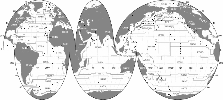
The map shows the delineation of Longhurst Biogeochemical Provinces with locations of sediment trap
deployments indicated by gray dots. The original EPS format
(size: 1.5 MB) is available as well as a smaller PDF file (size: 260 KB).
Longhurst A., Sathyendranath, S., Platt, T. and Caverhill, C. 1995,
An estimate of global primary production in the ocean from satellite radiometer data.
Jour. Plankton Res., 17, 1245-1277.
| Global Biogeochemical Domains and Provinces after Longhurst et al., 1995. |
| Domains |
Biogeochemical Provinces |
|
Moorings |
Traps |
| Polar Domain | BPLA | Boreal Polar | 7 | 9 |
| | ARCT | Atlantic Arctic | 14 | 35 |
| | SARC | Atlantic Subarctic | 1 | 1 |
| | BERS | North Pacific Epicontinental Seas | 3 | 8 |
| | ANTA | Antarctic | 14 | 30 |
| | APLR | Austral Polar | 12 | 14 |
| |
| Westerlies Domain | NADR | North Atlantic Drift | 14 | 30 |
| | GFST | Gulf Stream | | |
| | NAST | North Atlantic Subtropical Gyre
(West and East) | 22 | 33 |
| | MEDI | Mediterranean | 6 | 10 |
| | PSAG-W | Pacific Subarctic | 12 | 24 |
| | PSAG-E | Pacific Subarctic | 14 | 28 |
| | KURO | Kuroshio Current | 17 | 35 |
| | NPPF | North Pacific Polar Front | | |
| | NPST-W | North Pacific Subtropical Gyre-West | | |
| | NPST-E | North Pacific Subtropical Gyre-East | | |
| | OCAL | Offshore California Current | 12 | 12 |
| | TASM | TASMAN SEA | | |
| | SPSG | South Pacific Subtropical Gyre | | |
| | SSTC | South Subtropical Convergence | | |
| | SANT | Subantarctic | 4 | 7 |
| |
| Trade Wind Domain | NATR | North Atlantic Tropical Gyre | | |
| | WTRA | Western Tropical Atlantic | 1 | 1 |
| | ETRA | Eastern Tropical Atlantic | 20 | 33 |
| | CARB | Caribbean | | |
| | SATL | South Atlantic Tropical Gyre | 6 | 7 |
| | MONS | Indian Ocean Monsoon Gyres | 6 | 6 |
| | ISSG | Indian Ocean South Subtropical Gyre | | |
| | NPTG | North Pacific Tropical Gyre | 6 | 20 |
| | PNEC | North Pacific Equatorial Countercurrent | 13 | 26 |
| | PEQD | Pacific Equatorial Divergence | 3 | 10 |
| | WARM | Western Pacific Warm Pool | 10 | 17 |
| | ARCH | Western Pacific Archipelagic Deep Basin | | |
| |
| Coastal Domain | NECS | Northwest Atlantic Continental Shelf | | |
| | NWCS | Northwest Atlantic Continental Shelf | | |
| | CNRY | Canary Current Coastal | | |
| | GUIN | Guinea Current Coastal | | |
| | GUIA | Guiana Current Coastal | | |
| | BRAZ | Brazil Current Coastal | | |
| | FKLD | Southwest Atlantic Continental Shelf | | |
| | BENG | Benguela Current Coastal | | |
| | REDS | Red Sea and Persian Gulf | | |
| | ARAB | Northwest Arabian Upwelling | 5 | 14 |
| | EAFR | East Africa Coastal | | |
| | INDE | Eastern India Continental Shelf | 1 | 1 |
| | INDW | Western India Continental Shelf | | |
| | AUSW | Australia-India Coastal | | |
| | ALSK | Alaska Downwelling Coastal | | |
| | CCAL | California Upwelling Coastal | | |
| | CAMR | Central American Coastal | 5 | 7 |
| | CHIL | Chile-Peru Current Coastal | 2 | 3 |
| | CHIN | China Seas | 2 | 3 |
| | SUND | Sunda-Arafura Seas Coastal | | |
| | AUSE | Eastern Australia Coastal | | |
| | NEWZ | New Zealand Coastal | | |
| Totals | 232 | 424 |