SST_chl
PI: Frank Hoge
of: NASA/Goddard Space Flight Ctr., Wallops Island, VA
dataset: Aircraft observed sea surface temperature and chlorophyll
project/cruise: NABE/NASA P3 flight of May 21, 1989
platform: NASA P3 aircraft
Methodology
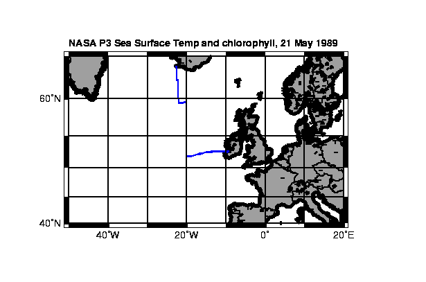
Flight track
Flight leg notes:
Flight leg 1
Starting Coordinates: 52 36.6 N 09 10.5 W
Ending Coordinates: 52 24.7 N 14 59.7 W
Flight leg 2
Starting Coordinates: 52 18.2 N 15 49.2 W
Ending Coordinates: 52 05.3 N 17 19.3 W
Flight leg 3 not reported
Flight leg 4
Starting Coordinates: 51 40.8 N 20 00.1 W
Ending Coordinates: 55 22.8 N 19 51.6 W
Flight leg 5
Starting Coordinates: 55 42.3 N 19 59.8 W
Ending Coordinates: 59 32.1 N 20 03.5 W
Flight leg 6
Starting Coordinates: 59 32.4 N 20 04.6 W
Ending Coordinates: 59 40.6 N 22 01.3 W
Flight leg 7
Starting Coordinates: 60 01.0 N 22 03.6 W
Ending Coordinates: 63 52.3 N 22 43.7 W
Parameter Description Units
leg cruise or flight track segment
identification
time GMT time (seconds of the day) seconds
(May 21, 1989)
lat latitude, minus = South decimal degrees
lon longitude, minus = West decimal degrees
temp_sst temperature, sea surface, from decimal degrees C
infrared radiometer
LIF Raman normalized Laser-Induced
Fluorescence (LIF) ratio
chl chlorophyll as calculated from micrograms/liter
LIF ratios