
US JGOFS-SMP

WOCE/JGOFS/OACES Global CO2 Survey
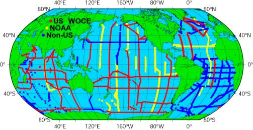
| This is a map of the
station locations from the global survey which have carbon measurements. The
red stations indicate measurements collected as part of the US WOCE one time
survey. The yellow stations were a part of NOAA’s OACES program. We have also
made an effort to incorporate as much international data as possible. The
blue stations in the Indian Ocean are from the French. Pacific data came from
the Australians, Japanese, and Canadians. Much of the new Atlantic work was
performed by the Europeans. The synthesis began in the Indian Ocean. These
cruises had the best coordination are required the least effort to
synthesize. We have just completed the Pacific synthesis and are now moving
on to the Atlantic. All together we hope to have something on the order of
100,000 unique sample locations with at least two measured carbon parameters. |